Accurate data. Clear documentation. Reliable results.
High Ground Aerial provides professional drone services for businesses that need usable aerial data, not just photos.
We specialize in inspections, documentation, and mapping that help clients make informed decisions, reduce risk, and monitor progress.
Based in Morrison, Tennessee, we proudly serve clients throughout Middle Tennessee.
Professional Drone Services for Commercial & Property Projects

Our Services
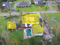
Roof & Property Inspections
Safer. Faster. More detailed than traditional inspections.
Drone inspections allow you to assess roofs and properties without ladders, lifts, or shutdowns. We capture high-resolution imagery that clearly documents damage, wear, drainage issues, and structural concerns—ideal for evaluation, planning, and reporting.
Common use cases:
-
Roof condition assessments
-
Storm and damage documentation
-
Property maintenance planning
-
Insurance and pre-repair documentation
Why clients choose this service:
-
Eliminates safety risks
-
Saves time and labor
-
Provides clear visual records
-
Faster turnaround than manual inspections

1
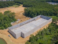
Construction Progress Documentation
Consistent aerial records from start to finish.
We provide scheduled drone documentation to track construction progress over time. Our imagery gives stakeholders a clear view of site activity, milestones, and logistics—without needing to be on site.
Common use cases:
-
Weekly or monthly progress updates
-
Stakeholder and investor reporting
-
Site coordination and planning
-
Historical project documentation
Why clients choose this service:
-
Repeatable, consistent results
-
Improves communication
-
Reduces site visits
-
Supports accountability and planning

2
Mapping, 3D Modeling & Photogrammetry
Accurate aerial data for planning, measurement, and analysis.
This service goes beyond visuals. Using photogrammetry, we create measurable maps and 3D models that support development, construction, and engineering workflows.
Common use cases:
-
Orthomosaic site maps
-
3D models of structures or land
-
Volume measurements
-
Planning and documentation support
Why clients choose this service:
-
Accurate spatial data
-
Clear visual context
-
Supports engineering and planning decisions
-
Differentiates from standard drone photography
3


Commercial Aerial Imaging & Documentation
Professional aerial imagery for business use.
This service covers commercial properties and facilities that need clear aerial documentation for records, planning, or presentation. It’s ideal when visuals are needed—but safety, compliance, and consistency still matter.
Common use cases:
-
Facility overviews
-
Asset documentation
-
Property marketing support
-
Internal reporting and presentations
Why clients choose this service:
-
Professional-grade results
-
Commercial focus (not hobby photography)
-
Compliant and insured operations


4